Saturday, August 21, 2010

Klondike Highway


The Klondike Highway connects Whitehorse to Skagway. The highway closely matched the route miners took to reach Dawson City (Klondike gold rush town) from Skagway. This was not the most direct route toward the gold claims but it was the easier route to cross the mountains. After the Chilkoot pass, the miners took advantage of the water system to travel toward Whitehorse and the Yukon River. This became the path the railroad took. Once the railroad route was chosen, all other trails ceased to attract miners. Dyea, the town near the steeper portion of Chilkook Pass, was the starting point for the more dangerous and more direct route to the gold fields. Miners died on the Dyea trails as they crossed the mountains. It was the Dyea route that was often pictured in newspapers during the early portion of the gold rush. The picture was of an icy staircase full of miners one after another climbing up the mountain. The Mounties patrolled this route. No one was allowed up the pass without 2000 pounds of supplies; the amount necessary to live for at least three months. Some people took over a month to bring their supplies up the mountain. The Klondike gold rush played an important part in the history of this area.

The Klondike Highway was lightly populated, similar to our experience on the Alaska Highway.

Again the scenery was spectacular. It is only 130 miles between cities. We took our time as we journeyed this historical route. Glaciers displayed their presence in the mountains as well as through the color of the lakes, the bright turquoise glacial water color.


We stopped by Carcross to take a picture of the oldest operating store in the Yukon. Carcross was not much to look at; the store was the most colorful building.


After Carcross, it was more amazing scenery until we reached Skagway. As we were traveling the Alaska and Klondike highways we were listening to a book on tape describing building the Panama Canal. For some reason seeing the rough terrain that miners and road engineers had to take to reach the Yukon River and hearing about the rough circumstances folks endured to build the canal merged into a compatible visual-oratory experience.

The Canadian border ends about 10 miles before the U.S. Customs stop. This border crossing had no long lines of cars causing us delays. Instead our crossing was slow due to our carelessness in having fruit and cherry tomatoes in the car. We had to wait for the agriculture inspector to inform us if we could take our apples and cherry tomatoes into Canada. The cherry tomatoes were tossed and the apples were kept.
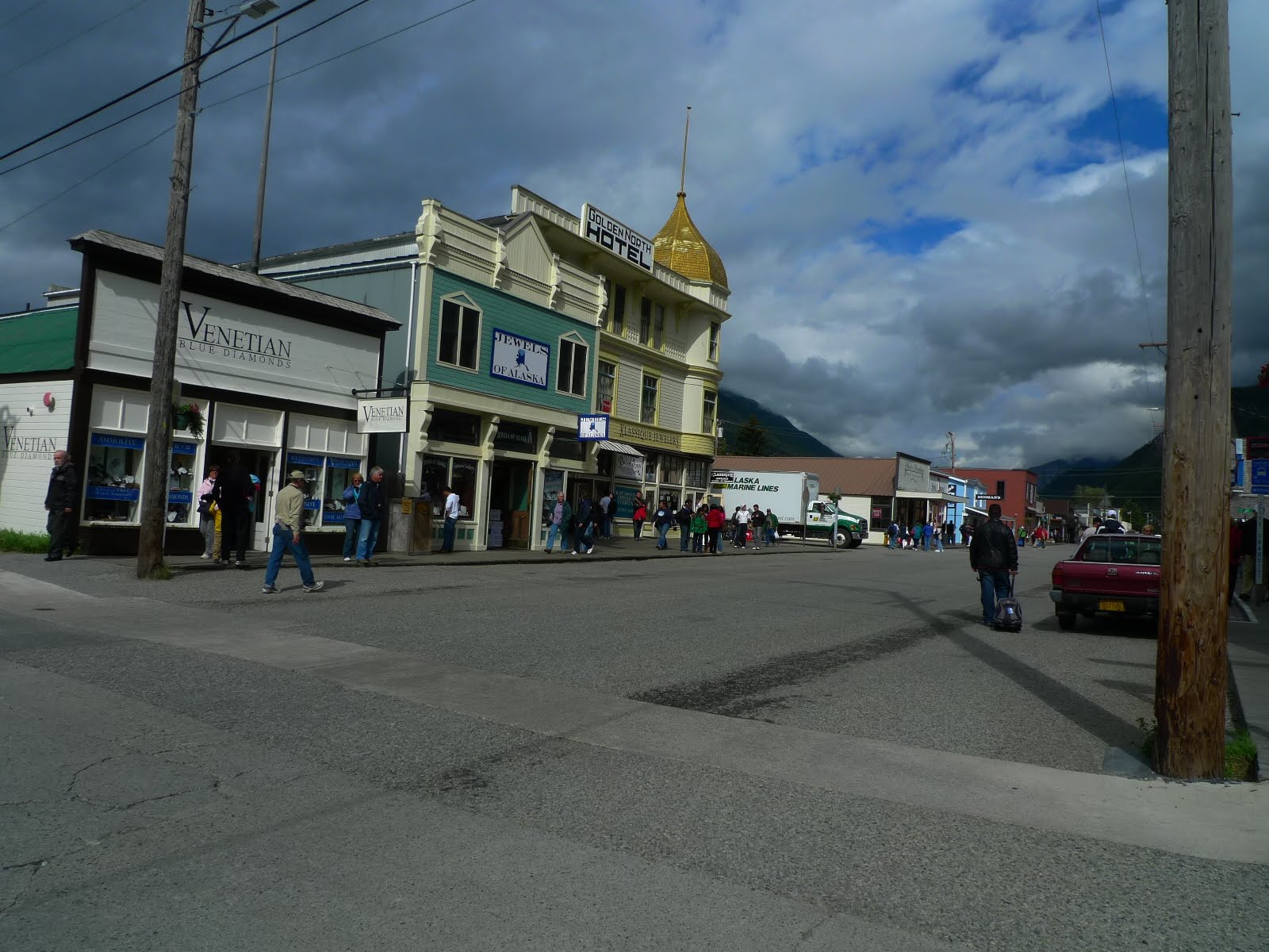

Skagway was in the height of cruise ship traffic when we arrived. There were 5 cruise ships in dock. The town was crawling with tourists. This is a town that prides itself on selling cheap jewelry, 1 ct diamonds for $700. Eight out of ten stores in the blocks closest to the port sold jewelry. The downtown sidewalks were wood planks. Only one gas station was operating. We bought some smoked fish after tasting the wares. This was a family run operation that produced some of the tastiest smoked salmon, halibut and other fish. The jewelry stores left us cold; the jewelry looked tacky. The popular t-shirt store (many cruisers were seen walking back to their ships with bags from this store) was full of cheap goods; a cap manufactured in China with the word Alaska on it could be purchased for less than $2.00. The Tourist Center in town showed a good movie about the gold rush. It was a highlight of our entertainment in Skagway. After the cruise ships departed at night, the town was empty. That was when these pictures were taken.

Dinner at the local fish restaurant was superb! Here was a picture of the food, no description, only an image.

Tuesday, August 17, 2010

Whitehorse, Yukon Territories


Leaving Watson Lake we headed west, south, northwest to Whitehorse. In our meandering to get to Whitehorse we re-entered British Columbia for a short period. There was a massive fire south of Watson Lake. We saw the cars lined up waiting to be led through the burn area south towards Prince George. There were not many roads in upper B.C. and Y.T. One group we talked with at the hotel had to go south through the fire area to get to Vancouver for their flight to Australia. If the road was closed they would have to backtrack and would lose several days time. We learned that you do not want to be on the roads after 8pm. Gas stations close, there are no hotel rooms available and the wild animals come out.


Smoke from the fire obscured our views. We were very glad when we started heading northwest away from the smoke. The mountains off in the distance provided us with some impressive landscapes. Highway signs were scarce. There were no notifications of the territory changes between B.C. and Y.T. along the route. Nor was there any sign informing us of the watershed sending water to the Pacific rather than the Arctic. Another missing notification was when we crossed the 60 degree latitude. (On a different vacation when I traveled to the Northwest Territories there was a sign informing us that we had crossed the 60 degree mark. The Arctic Circle is at 66 degrees latitude.) We had to depend upon our maps to know these informative facts.


Some of the trees were beginning to change color; however the official start of Autumn was not due for another 5 weeks. The weather we experienced was mild. We had the best weather from Watson Lake to Whitehorse. Shorts were the appropriate clothing that day.


Upon arriving in Whitehorse the sign and Yukon River appeared simultaneously. Whitehorse was named from the white rapids on the Yukon River flowing through the city. Yukon Territories has a population just short of 32,000 people. 25,000 folks live in Whitehorse. The town hosts two theaters, several food stores, all kinds of car dealerships, museums, restaurants and many tourist shops. Twice a week a direct flight arrives from Germany. Even with all the tourist prosperity, there remains a depressed feeling amongst a portion of the native population. Evidence of problems with alcohol were seen in the people and billboards. Our hotel was next to a bar that opened at 9am every morning. It was common to see women hanging around the bar.

There was a local town brewery, Yukon Beer. We took a tour of the brewery. The beer was very good. They were very generous with their tastings. Guess that does not help the alcoholism problem in the area. All the art work for their labels and t-shirts was done by local artists.

A restaurant recommended to us offered some of the best food we'd had since our farewell lunch at Pyramid Lake in Jasper. We ended up eating at the Klondike Rib and Salmon Barbecue both nights. The food lovers will want to know what we ate. I had some barbecue ribs the first night. Bill had some delicious chowder the 2nd night, the first night he had fish and chips. Sandy had a cod dish that was very tasty. The vegetarian dinner offerings were delicious; I feasted on one of the vegetarian dishes for my second meal. A vegan bakery in town offered tasty coffee drinks and breakfast breads. We enjoyed the food and hospitality of Whitehorse. Whitehorse enjoyed our tourist money.


The MacBride Museum featured history during the gold rush period and beyond. Stuffed animals from the area were displayed; we confirmed it was mountain goats that we saw along the road. Sam McGee's cabin, Sam McGee from the poem "The Cremation of Sam McGee", was replicated and housed on the museum property. The history of the gold adventurers was interesting, especially the women who came to the Yukon. Women could not make a claim or own a saloon but they came here to change their fortune. One woman left her husband and kids in Chicago; she traveled with her brother to search for gold. The interesting stories were plentiful.


Here were pictures of 2nd Street and an interesting building adornment. We never did find out why the fighting moose were displayed on the roof.

Whitehorse and all the towns up north had amazing flower displays.

Monday, August 16, 2010

Alaska Highway - Dawson Creek to Watson Lake Part 2

Here are some more pictures from travels between Fort Nelson and Watson Lake.

We stopped to visit Muncho Lake. At one time we thought that we would camp here. The drive from Fort Nelson to Muncho Lake took us over 2 hours. We were very glad that we made the decision not to push beyond Fort Nelson the previous day. If we could not have found a campsite, it would have been a disaster. A local told us that we could camp along the highway but we would have to watch out for bears. That news was enough to discourage us from thinking about road side camping. The towns on the Alaska Highway were few and far between. Muncho Lake water was a gorgeous color and very clear. There did not seem to be anything living in the lake, no plant life, no fish. Signs did state that one could fish but we did not see any evidence of fish.


I swore that I would not take any animal pictures, taking a picture would turn them into vistas rather than living creatures. I could not resist taking a picture of these bison after the highway sign warned us of bison on the road. Canadian signs have been great; we have seen signs warning us of crossing deer, elk, moose, bison, horses without riders, horses with riders, mountain sheep, red fox, and bear. These signs were very specific in depicting the animals. These bison were meandering along the side of the road. It was great to see the little ones with the big ones. We have also seen mountain goats, bears and elk along the route. (I saw moose in Newfoundland.) Another sign that was displayed along the highway was the sign indicating that the road was becoming gravel.


The Alaska highway takes us into Yukon Territories (Y.T.) from British Columbia (B.C.). Then we go back into B.C. for a short drive until returning to Y.T. The only way we knew we were in Y.T. the first time was the sign on the left, not exactly the impression sign welcoming visitors to the Yukon. The sign on the right was the second sign we saw when coming back into the Territory. We stayed Watson Creek Y.T. that night.


Watson Creek is known for its sign park. People bring signs from all over the world and tack them to posts in the park. The idea for this park originated from a homesick soldier's request. He missed his home in Bismark, North Dakota. Word spread about his homesickness for Bismark. Folks sent him road signs from Bismark. The idea grew and soon signs were posted from all over the globe. This picture represents only a small fraction of the park.


In Watson Creek it was recommended that we spend the night in the Air Force Lodge.

This hotel was owned by a German immigrant to Canada. Michael was very interesting and friendly. He acquired the buildings for little money. They were falling apart. He spent over two years reconstructing them to modern specs while re-using the old materials. The windows were all triple pane and the insulation was updated as well. The layout of the building and the beams were all originals. The furniture looked original as well. Michael had a high powered job in Germany. He worked with his father and they were planning on expanding the company. Michael's father was diagnosed with colon cancer and died six weeks later. Michael sold everything and immigrated to Canada. He had been to Canada for business dealings and enjoyed the country. He moved up to Y.T., met his wife and started the hotel. He works very hard for five months of the year, then relaxes the remaining seven months. The place filled up as we were chatting with him. Watson Creek has limited accommodations. There are only about 1500 people living within the town limit.

This was the town's department store. That night we went to the Northern Lights Museum to see a video about the Aurora Borealis. There were some great pictures in the video. The theater had very comfortable seats. I was surprised to find a building of this size and comfort in the town. Michael told us that the Watson Lake community enjoys viewing movies here in the winter months.

Sunday, August 15, 2010

Alaska Highway - Dawson Creek to Watson Lake Part 1


Before thinking about taking the trip up the Alaska Highway I read reports about it. The articles told of the road being a steady stream of RVs housing recent retirees. They labeled the trip as a rite of passage. I imagined bumper to bumper RVs. Guess what? The road has been a pretty lonely during long stretches of highway. We have seen RVs and big trucks but never enough to feel that we were part of a cattle train. Pictures speak more eloquently than I.

Dawson Creek was a big city by Alaska Highway standards. Our Comfort Inn hotel was one of many offerings in the town and it was very comfortable.

Shortly after leaving Dawson Creek, we diverted toward the old Alaska Highway road to see the curved Kiskatinaw Bridge. This was a wooden bridge, 534 ft in length with a 9 degree curve. This bridge was made entirely from wood. It was bit scary to cross and very impressive from the other side. This was the only remaining wooden bridge left from the original road construction.

Further down the highway, in Taylor, we missed the vegetable market. Taylor was a natural gas town and the heavy duty power plants distracted us from seeing any signs about fruits and vegetables. Luckily we had stored up on fresh produce before reaching Dawson Creek.

After Taylor we drove and drove and drove some more. (I have driving pictures from the road and have uploaded only the best pictures.) Finally we came into Fort Nelson. This town reeked of dust. Many of the inhabitants work in the lumber or energy business. They drive long distances along dirt roads for their jobs. We also encountered some very dusty road construction before arriving in Fort Nelson. (In the construction zone, dust from the truck ahead of us was so dense that Sandy, the driver, could not see beyond 30 feet. It was a car joke that when Sandy got behind the wheel we would experience bad weather or bad road conditions or bad traffic.) The town's self service car wash was a popular spot for locals as well as visitors. I begged them to allow me to wash my car after hours. The hotel was pleasant. After settling in, we walked around town. Found the most wonderful health food store. The woman running it was very friendly. She gave us the Fort Nelson news and her history. She had a high paying job with a lumber company and gave up her job to setup this health food store. The store also has organic baby products. She claimed the town supports her work and she is planning on expanding the store. She and the woman at the hotel both complained about the lack of a bookstore in town. That night we ate at Dan's Neighborhood Pub; it was quite pleasant. They offered poutine as a side dish option. Poutine is french fries covered with a cheese sauce then smothered in gravy. None of us tried this rich dish though we have been assured it is quite tasty.


With Fort Nelson behind us we started to see some interesting scenery. The road was heading into the upper Rockies. Notice the plethora of traffic in these pictures. The mountain in the picture on the right has a rock top that is rippled. The earth dynamics that caused the rippling was a mystery to us.

Saturday, August 14, 2010

Getting Dry and Going to Mile Zero of the Alaska Highway


As we headed toward Dawson Creek the weather changed. The rains stopped. Soon it was warm and sunny. We found a place along the route to dry our tents. Bill was embarrassed about us drying the tents along the road. I was happy to have them dry so that we could pack them away.

Grand Prairie, in northern Alberta, was a large city. There were residential areas, subdivisions of houses. We have not seen subdivisions since Calgary. We were surprised to see such a prosperous city this far up north.

Along the way we saw an enormous beaver. Don't know this was the biggest beaver. There was no sign informing us about this large bucked tooth creature. We were left wondering why a town would host this statue.

Dawson Creek was as expected. A medium-sized, dusty town filled with motels. This was Mile Zero of the great Alaska Highway. The Days Inn was clean, quiet and wonderful. There was a washer and dryer in the hotel; we now had clean clothes. It was amazing how a shower and comfortable bed improved our outlook about the trip. (The clean clothes and dry tents also helped us feel that we were ready to tackle the infamous highway.)

Jasper National Park


The campsite in Banff, Lake Louise Campground, was very comfortable. It was also a very crowded, large campground. In Jasper we stayed at Wabasso Campground. This out-of-the-way campsite was close to a hike, Edith Cavell Meadows, that was a must-do item according to the Frommer's traveler's guide for Jasper National Park. Our last night at Lake Louise campground left us damp. We arrived at Wabasso to warm sunshine. Fifteen minutes after setting up our campsite, all our tents and towels were dry. We basked in the sunshine. Wabasso campground was on the Athabasca River. It did not have any showers. We asked at the campground entrance station if we could swim in the river. The park employee informed us that we would be swept away if we tried to swim in the river. After seeing the river's currents, we understood why the ranger told us to beware of the river. Here is a picture of the river and our group of happy campers.

The next day we hiked the Edith Cavell Meadows trail. Edith Cavell was a British nurse during WWI. She was told to leave an area due to the heavy fighting. Instead of leaving, she stayed to help nurse the injured on both sides. During this time she helped over 200 people escape German occupied Belgium. She was captured, tried for treason and executed by the Germans. Her death made world wide news. Canada wanted to honor her by naming the tallest mountain in the Athabasca range after her. On the mountain is a glacier called the Angel Glacier. The hike to the meadows opposite the mountain and glacier was beautiful. I could see why Frommer's Guide recommended this hike. The flowers along the path were in full bloom. We saw some marmots and a pica. The main attraction was the mountain, glacier and the pond below the glacier. The pond was full of pieces of ice that had broken off either from the mountain glaciers or from the glacier near the pond.
Note the greenish glacier color in the water. Sandy was posing for this picture. This hike was enjoyed by all (this was not true for some of our hikes).

After the hike and lunch most of the group went to the hot springs east of Jasper. These hot springs fed water into two large pools. You paid for the use of the pools: two small cold and two large hot pools. The pools varied in temperature, the cold pools were several degrees different from each other. The same was true for the hot pools. The setup of the hot springs was efficient. You could rent a swimming suit and/or towel if you needed one. The pools were large enough to hold a lot of people. Visitors here spoke a wide range of languages; we spent some time trying to place the languages being spoken. After our hike, these hot and cold pools were a treat for our muscles.

Our favorite place in Jasper was the laundromat. This laundromat offered laundry services, internet connections, a place to recharge appliances, a shower, coffee and sweet treats. It was a wonderful place to visit. There were games to occupy patrons who were not using the internet.

At the campsite, we had a fire every night. Anna was an expert marshmallow roaster. She offered us perfectly roasted marshmallows. We would sit around the picnic table and play cards until bed time. There were no star gazing nights as the night skies were cloudy.


Dinners were at restaurants in Jasper. There were no memorable meals until the day when most of the party left. Anna, Rahul, Shreyas and Todd were heading back to Calgary to catch flights back home. On our last day together we wanted to go for one more hike. The continual drizzle of rain put a damper on that plan. Instead we drove to Pyramid Lake for sightseeing and lunch. This was a spontaneous plan. We were fortunate to find a beautiful wood lodge that offered lunch. It was an excellent meal. It was sad to see our friends depart for home.


Later that afternoon, the rains stopped. Bill, Sandy and I wanted to see some more sites. We went to Athabasca Falls. As usual, the Canadian park system had a great setup for viewing the falls. We could see these powerful falls from afar or at close range. Another lookout point allowed viewing of the water cutting a path through the rocks. We regretted not showing this place to the others before they left. The falls were about fifteen minutes from our campground.

That evening and all through the night it drizzled. We woke up to rain falling on our tents. This was the day we were packing up to head for the Alaska Highway. We did our best to get most of the items dried in a campground shelter. (Most campgrounds offered an open building with picnic tables and a stove for communal use. This allowed campers a place to cook and eat when it was raining.) We used this space to warm up, eat breakfast and try to dry some of our equipment. Our tents were soaked. We packed them up wet. Using the laundromat to dry our tents crossed our minds until we realized the impracticality of it. We had to get our camping equipment dry.

The Road from Banff to Jasper


This road was reputed to be the most scenic road in Canada. After driving it, I concurred. Every kilometer offered a new beautiful site. I have rarely seen such awesome vistas. Here pictures speak louder than words. These pictures represent only a small number of the ones taken or the scenery experienced. Everyone in our group was blown away by the splendor. This place should be put on everyone's vacation list.


The glacier in the picture on the right is deeper than the Eiffel tower is tall. We did not pay the money to travel across the glacier via a bus. About that time we were ready to setup our camp in Jasper.